Digital data
Ground subsidence of Urayasu City liquefied in the March 11th, 2011 Great east Japan Earthquake
The 0.5m × 0.5m digital models of ground subsidence for liquefied Urayasu City in Arc-ASCII grid format can be downloaded from the map below.
Right click on any clickable area of the map and choose "Save link as" to download the Arc-ASCII grid formatted digital model.
The downloaded model can be viewed on any of GIS software shown below.
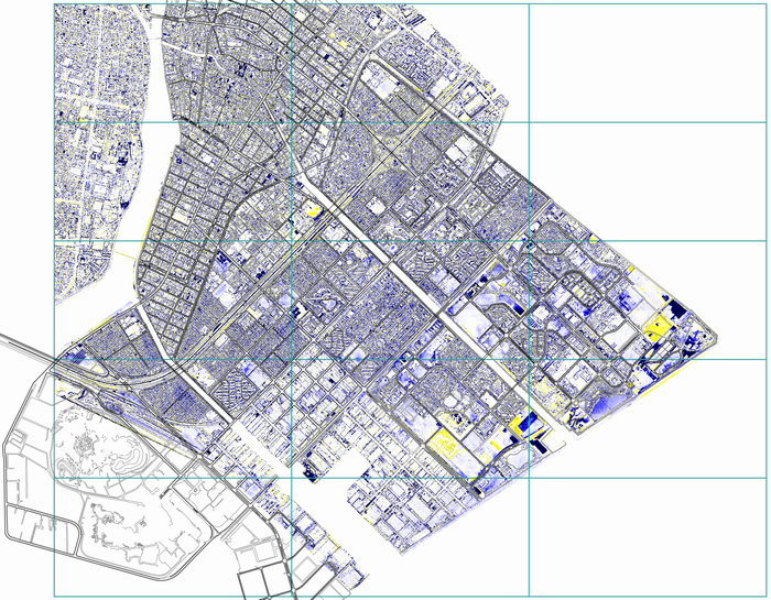 -37000m
-38000m
-39000m
-40000m
-41000m
-42000m
4000m
6000m
8000m
10000m
df_1_1.asc
df_1_2.asc
df_2_1.asc
df_2_2.asc
df_2_3.asc
df_3_1.asc
df_3_2.asc
df_3_3.asc
df_4_1.asc
df_4_2.asc
df_4_3.asc
df_5_1.asc
df_5_2.asc
-37000m
-38000m
-39000m
-40000m
-41000m
-42000m
4000m
6000m
8000m
10000m
df_1_1.asc
df_1_2.asc
df_2_1.asc
df_2_2.asc
df_2_3.asc
df_3_1.asc
df_3_2.asc
df_3_3.asc
df_4_1.asc
df_4_2.asc
df_4_3.asc
df_5_1.asc
df_5_2.asc
Clickable index map for downloading Arc-ASCII formatted digital models of ground subsidence in Urayasu
- Projection system: Tokyo / Japan Plane Rectangular CS IX (Authority ID: EPSG 30169)
- File size: 6 to 47MB
- Arc-ASCII formatted file for the entire Urayasu (718MB) can be downloaded from here
- Zipped shape files for road edge lines, railways, shore lines, rivers and water surfaces (polygons to mask noise from water surfaces) can be downloaded.
Digital elevation models for active folding mountain terrains
External link to Earthquake damage in active folding areas:
GIS software
- Global Mapper (payware): Global Mapper is an easy-to-use GIS Data processing application. One of the unique and defining characteristics of Global Mapper is its extensive and varied data format support, offering direct access to over 200 different raster, vector, and elevation data types.
- Quantum GIS (freeware): Quantum GIS (QGIS) is a user friendly Open Source Geographic Information System (GIS) licensed under the GNU General Public License. QGIS is an official project of the Open Source Geospatial Foundation (OSGeo). It runs on Linux, Unix, Mac OSX, Windows and Android and supports numerous vector, raster, and database formats and functionalities.
- MapWindows (freeware): The MapWindow GIS project includes a free and open source desktop geographic information system (GIS) with an extensible plugin architecture; a GIS ActiveX control; and C# GIS programmer library called DotSpatial.